|
LOCATION
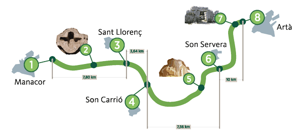
Between the towns of Manacor and Arta, located in the east of the island of Mallorca
Illes Balears
BALEARIC ISLANDS
Municipalities: Manacor, Sant Llorenç des Cardassar, Son Servera and Arta
Length: 29 Km
Users:  
Accessibility level: no information no information
Type of surface:
Compacted gravel
Natural landscape:
|
|
|
Along the greenway there alternate cereal crops, orchards and plantations of carob, orange, olive, fig (carabassets) or almond, with Mediterranean forest of wild olive, Aleppo pine, mastic and rosemary; the characteristic landscape of Serres de Llevant. Along the way it has done important work of reforestation. On its margins there have planted 4,800 trees (pines, oaks, wild olives, tamarind, banana and mulberry) and more than 15,000 shrubs.
The route passes close to the beaches of San Llorenç des Cardassar (S'Illot, Sa Coma and Cala Millor) and Son Servera (Cala Millor, Cala Bona and Costa de los Pinos), the nature reserve of Punta n'Amer, the Serra de Sant Jordi and the natural park Llevant Peninsula.
Other natural areas of interest:
Manacor: Mas des S'Estany beaches, Cala Anguila, creek Mendía, lime de Mallorca, S'Illot, Porto Cristo and Cala Murada.
Arta: Nature Reserves Ferrutx Cap and Cape des Freu and Llevant Marine Reserve
Cultural heritage:
Manacor: Historic Area (known as Ses Dames) that emphasize the church of Mare de Deu dels Dolors, the tower of Palau, the convent of Sant Visenç Ferrer and the tower of Ses Puntes. In the surroundings you can see the tower Enagistes (Museum of History), the Talayotic settlement of s'Hospitalet Vell and the early Christian basilica of Son Peretó (a 200 m. From the greenway). Cuevas del Drach and Hams (hooks).
Sant Llorenç des Cardassar: Rustic Village, Church of Sant Llorenç and house Ses Sitges. On the coast lies the castle of Punta n'Amer.
Son Carrio: Church of San Miguel.
Son Servera: New church, interesting discoveries des Puig, Pula and ca s'Hereu, church of Sant Joan Baptista, laundry, market, port of Cala Bona and coastal lookout des Pins.
Arta: talaiotic Remains of Ses Païses and Son Real, strength-sanctuary of San Salvador, documentation center Miquel Barceló, Regional museum, manor houses of Marqués, Cardaix and Sureda, Betlem Hermitage, nurseries and fishing port of Colonia de Sant Pere, Monastery of Santa Maria de Bellpuig and the foundation Aina Maria Lliteras of Can Cardaix.
Infrastructure:
Greenway. 3 tunnels and 4 stations
Infrastructure Equipments:
8 rest areas with benches, tables, bicycle parking and rubbish bins.
Information panels with points of interest and information on vegetation and fauna.
15 surveillance cameras.
Equipment in stations:
-Station Of Sant Llorenç: parking area and playground.
-Station Of San Miguel (Son Carrio) parking area and urban park.
-Station Of Arta: Travelers building in use as a center of craftsmanship and another building as bar-pub.
Soon the stations will welcome new uses of restoration.
|